Councils and government
Fleet data you can stand behind
For councils and government agencies running cars, trucks and plant across several depots, where every vehicle and every kilometre may need explaining to someone outside the fleet team.
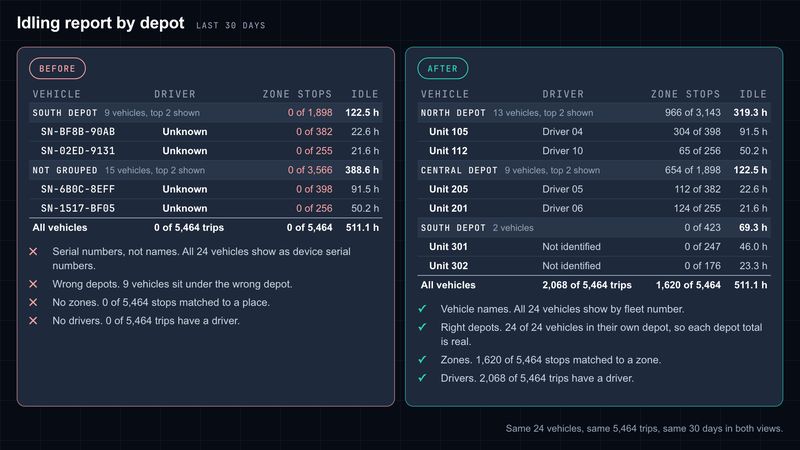
Example built on Geotab demonstration data. No client data is shown. The “before” view was set up badly on purpose to show common faults.
What we hear from fleets like yours
Sound familiar?
Every depot set up differently. Cars, trucks and plant added over the years by different people, each in their own way.
Questions that take a week to answer. A councillor or auditor asks something simple, and the numbers have to be pieced together by hand.
Reports that don't survive a second look. They hold up inside the fleet team, and fall apart when finance or an auditor reads them.
What we'd look at first
Where we'd start
- Groups that match your depots and cost centres, so every vehicle and every kilometre lands in the right place.
- Driver identification, so after-hours and private use can be explained trip by trip.
- Zones for depots, works yards and waste facilities, so stops have names in place of map coordinates.
How the pillars fit
How we help
Configuration
A set-up you can explain line by line, for a fixed fee agreed up front.
MyGeotab as a service
Users, vehicles and groups kept in order as staff and plant change, with regular plain-language reports and a quarterly review.
Projects
Fleet data connected to your finance and asset systems, and dashboards that answer the questions you get asked.
Free data health check
Start with a free health check
Find out how your set-up would stand up to scrutiny before anyone else asks. You get a two to three page written report on your top five problems, then a 30-minute call. It's free, and it's not a sales pitch.